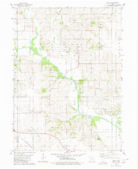
1980 Map of Peoria
USGS Topo · Published 1980About this map
The Peoria community serves as the primary hub for this agricultural landscape, situated along the banks of Little Creek in the townships of Richland and Black Oak. The local social fabric is grounded by the Christian Sch and several family-named burial grounds like Appel Cem and Baldwin Cem. Natural water systems dominate the terrain, notably the winding South Skunk River, which is supported by a localized Fish Hatchery and several active quarries.
Find a feature on this map
29 named features on this map. Tap any name to fly to it.
Don’t see what you’re looking for? This feature index may not catch every label — zoom into the map to look around manually.
Map Details
Editions of this 1980 Peoria Map
This is the sole edition of this map. No revisions or reprints were ever made.
Other maps of this area

1910 · Pella
USGS Topo · 1:62,500

1912 · Pella
USGS Topo · 1:62,500

1954 · Des Moines
USGS Topo · 1:250,000

1956 · Des Moines
USGS Topo · 1:250,000

1957 · Des Moines
USGS Topo · 1:250,000

1968 · Oskaloosa
USGS Topo · 1:24,000

1969 · Des Moines
USGS Topo · 1:250,000

1979 · Searsboro
USGS Topo · 1:24,000
1980 · Leighton
USGS Topo · 1:24,000

1980 · Sully
USGS Topo · 1:24,000