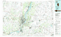
1985 Map of Peoria
USGS Topo · Published 1985About this map
The Illinois River corridor anchors this mid-1980s landscape, widening into Upper Peoria Lake and Peoria Lake as it passes the urban centers of Peoria, East Peoria, and Pekin. This era shows a complex industrial and transport network, where the Atchison Topeka and Santa Fe Railroad and other major lines intersect with developing modern thoroughfares like Interstate 74. To the west, the presence of the Stark Mine and various unlabeled strip mines reveals the footprint of the region's extractive history near Elmwood.
Find a feature on this map
154 named features on this map. Tap any name to fly to it.
Don’t see what you’re looking for? This feature index may not catch every label — zoom into the map to look around manually.
Map Details
Editions of this 1985 Peoria Map
This is the sole edition of this map. No revisions or reprints were ever made.
Other maps of this area

1893 · Lacon
USGS Topo · 1:62,500

1893 · Metamora
USGS Topo · 1:62,500

1893 · Dunlap
USGS Topo · 1:62,500

1898 · Dunlap
USGS Topo · 1:62,500

1905 · Peoria
USGS Topo · 1:62,500

1912 · Canton
USGS Topo · 1:62,500

1925 · Havana
USGS Topo · 1:62,500

1925 · Streator
USGS Topo · 1:62,500

1926 · Normal
USGS Topo · 1:62,500

1927 · Streator
USGS Topo · 1:62,500