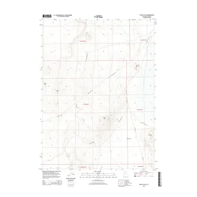
2014 Map of Peplin Flats
USGS Topo · Published 2014About this map
The high desert terrain of Box Elder County is defined by prominent peaks like Baker Mtn and Peplin Mtn, which rise above the expansive Peplin Flats. This 2014 survey captures a landscape of remote mountain ranges and vital desert water sources, such as Peplin Pond. The presence of Emigrant Trail Rd suggests the enduring historical significance of this corridor for western migration, tracing a path through the basin between Table Mtn and the southern Baker Hills. Small settlements such as Peplin and Ombey serve as quiet outposts in an area primarily crisscrossed by specialized routes like Peplin Mountain Rd and the Baker Mountain Loop. These roads facilitate movement through the varied elevations of the t11n r12w township, where the topography transitions from flat basins to the steep slopes of Crocodile Mtn in the southeast.
Find a feature on this map
21 named features on this map. Tap any name to fly to it.
Don’t see what you’re looking for? This feature index may not catch every label — zoom into the map to look around manually.
Map Details
Editions of this 2014 Peplin Flats Map
This is the sole edition of this map. No revisions or reprints were ever made.
Other maps of this area

1954 · Brigham City
USGS Topo · 1:250,000

1958 · Brigham City
USGS Topo · 1:250,000

1959 · Kelton Pass
USGS Topo · 1:62,500

1959 · Park Valley
USGS Topo · 1:62,500

1962 · Brigham City
USGS Topo · 1:250,000

1969 · Peplin Flats
USGS Topo · 1:24,000

1969 · Crocodile Mtn NE
USGS Topo · 1:24,000

1969 · Hogup Bar
USGS Topo · 1:24,000
1969 · Crocodile Mtn SE
USGS Topo · 1:24,000

1971 · Matlin
USGS Topo · 1:24,000