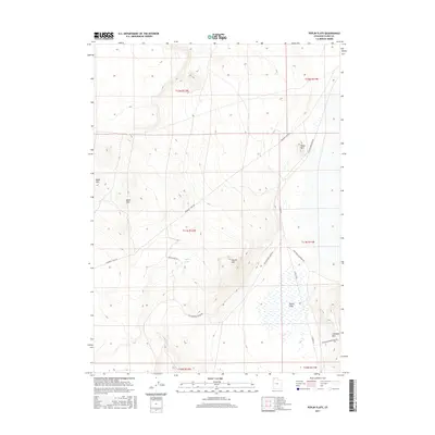
2017 Map of Peplin Flats
USGS Topo · Published 2017About this map
The vast salt basins of the Peplin Flats dominate this corner of Box Elder County, where the desert landscape is punctuated by a network of historic transit corridors. The high ground of Baker Mtn and the Baker Hills rises to the west, while Peplin Mtn and Table Mtn provide landmarks across the scrubland. This survey preserves the alignment of the Emigrant Trail Rd, a modern legacy of the pioneer routes that crossed northern Utah. This path is intersected by the Old Railroad Grade Rd, reflecting the region's later industrial evolution. Water is a scarce and vital element here, represented by the ephemeral Peplin Pond and the Crocodile Mountain Spr near the base of Crocodile Mtn. These features illustrate the precarious balance of life and travel in the Great Basin, where early wagon tracks and steam-era rail beds dictated the human geography.
Find a feature on this map
19 named features on this map. Tap any name to fly to it.
Don’t see what you’re looking for? This feature index may not catch every label — zoom into the map to look around manually.
Map Details
Editions of this 2017 Peplin Flats Map
This is the sole edition of this map. No revisions or reprints were ever made.
Other maps of this area

1954 · Brigham City
USGS Topo · 1:250,000

1958 · Brigham City
USGS Topo · 1:250,000

1959 · Kelton Pass
USGS Topo · 1:62,500

1959 · Park Valley
USGS Topo · 1:62,500

1962 · Brigham City
USGS Topo · 1:250,000

1969 · Peplin Flats
USGS Topo · 1:24,000

1969 · Crocodile Mtn NE
USGS Topo · 1:24,000

1969 · Hogup Bar
USGS Topo · 1:24,000
1969 · Crocodile Mtn SE
USGS Topo · 1:24,000

1971 · Matlin
USGS Topo · 1:24,000