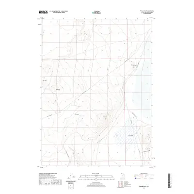
2020 Map of Peplin Flats
USGS Topo · Published 2020About this map
Peplin Flats and the surrounding desert peaks of Box Elder County are defined by a network of historical transportation corridors. The Emigrant Trail Rd cuts across the northern landscape, tracing a path used by travelers decades before the arrival of modern infrastructure. This route is mirrored by the Old Railroad Grade Rd, which snakes along the eastern slopes of Peplin Mtn and Crocodile Mtn, marking the path of former industrial rail development in the Great Salt Lake Desert region. Water remains a scarce and vital landmark in this arid terrain, evidenced by the presence of Peplin Pond. These isolated features, including the Baker Hills and Table Mtn, highlight the stark contrast between the flat alkali plains and the elevated ridges that provided the only reliable landmarks for early surveyors and travelers navigating northern Utah.
Find a feature on this map
12 named features on this map. Tap any name to fly to it.
Don’t see what you’re looking for? This feature index may not catch every label — zoom into the map to look around manually.
Map Details
Editions of this 2020 Peplin Flats Map
This is the sole edition of this map. No revisions or reprints were ever made.
Other maps of this area

1954 · Brigham City
USGS Topo · 1:250,000

1958 · Brigham City
USGS Topo · 1:250,000

1959 · Kelton Pass
USGS Topo · 1:62,500

1959 · Park Valley
USGS Topo · 1:62,500

1962 · Brigham City
USGS Topo · 1:250,000

1969 · Peplin Flats
USGS Topo · 1:24,000

1969 · Crocodile Mtn NE
USGS Topo · 1:24,000

1969 · Hogup Bar
USGS Topo · 1:24,000
1969 · Crocodile Mtn SE
USGS Topo · 1:24,000

1971 · Matlin
USGS Topo · 1:24,000