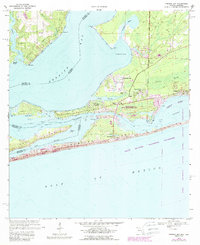
1970 Map of Perdido Bay
USGS Topo · Published 1988About this map
The coastal borderlands of Alabama and Florida meet along the waters of Perdido Bay, where this 1970 survey (with 1980s updates) captures a transition between residential growth and protected wetlands. Developments like Treasure Hill Park and Gulf Beach Heights appear alongside a complex network of bayous and flats, including Tarkiln Bayou and Kern Bayou. The map emphasizes the recreational and conservation character of the Gulf coast, highlighting the expansive Big Lagoon State Recreation Area and the Gulf Islands National Seashore stretching across the barrier island.
Find a feature on this map
41 named features on this map. Tap any name to fly to it.
Don’t see what you’re looking for? This feature index may not catch every label — zoom into the map to look around manually.
Map Details
Editions of this 1970 Perdido Bay Map
4 editions found
Other maps of this area

1921 · Bon Secour
USGS Topo · 1:62,500

1921 · Fort Barrancas
USGS Topo · 1:62,500

1941 · Fort Barrancas
USGS Topo · 1:62,500

1941 · Foley
USGS Topo · 1:62,500

1943 · Fort Barrancas
USGS Topo · 1:62,500

1943 · Foley
USGS Topo · 1:62,500

1944 · Perdido Bay North
USGS Topo · 1:25,000

1944 · Miflin
USGS Topo · 1:25,000

1944 · West Pensacola
USGS Topo · 1:25,000

1944 · Perdido Bay South
USGS Topo · 1:25,000
Featured Places
- Perdido Beach, AL
- Chanticleer, FL
- Gulf Beach Heights, FL
- Perdido Bay Country Club Estates, FL
- Treasure Hill Park, FL