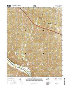
2016 Map of Perkinsville
USGS Topo · Published 2016About this map
The James River forms the southern boundary of this central Virginia landscape, a region defined by the convergence of Goochland, Louisa, Hanover, and Powhatan counties. The mid-2010s geography is characterized by rural crossroads and agricultural holdings, including the Virginia State Farm with its managed ponds like Virginia State Farm Pond Number One. Small settlements such as Perkinsville and Oilville sit along the primary corridors of Broad Street Rd, while the terrain to the south falls away toward the river basin. The drainage network is dense, with Beaverdam Cr and Horsepen Cr carving through the hills. Water management for local estates and agriculture is evident in named features like Mount Bernard Lake, Lake Fullstream, and Richmonds Pond, reflecting the evolution of the land from traditional tobacco and grain farming into modern residential and recreational parcels.
Find a feature on this map
113 named features on this map. Tap any name to fly to it.
Don’t see what you’re looking for? This feature index may not catch every label — zoom into the map to look around manually.
Map Details
Editions of this 2016 Perkinsville Map
This is the sole edition of this map. No revisions or reprints were ever made.
Other maps of this area

1890 · Goochland
USGS Topo · 1:125,000

1892 · Goochland
USGS Topo · 1:125,000

1943 · Goochland
USGS Topo · 1:31,680

1943 · Mabelton
USGS Topo · 1:31,680

1943 · Fine Creek Mills
USGS Topo · 1:31,680

1943 · Powhatan
USGS Topo · 1:31,680

1943 · Perkinsville
USGS Topo · 1:31,680

1943 · South Anna
USGS Topo · 1:24,000
1943 · Dabneys
USGS Topo · 1:24,000

1943 · Midlothian
USGS Topo · 1:24,000