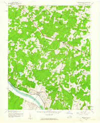
1943 Map of Perkinsville
USGS Topo · Published 1961About this map
Perkinsville and Oilville serve as small inland hubs in this mid-century survey of the Piedmont, where the rural landscape is defined by the winding course of the James River. Along the southern boundary, the Chesapeake and Ohio railroad corridor tracks the riverbank, passing through Thornehill and the State Farm facility. This transit and agricultural network connects isolated community centers like Crozier and Cardwell through a series of secondary roads and creek crossings. The spiritual and social life of these dispersed settlements is anchored by country churches such as Elpis Ch, Bethel Ch, and Hebron Ch. The map captures a period of Goochland County history before major suburban expansion, characterized by numerous drainages like Beaverdam Creek and Courthouse Creek that dictate the placement of local homesteads and farmsteads.
Find a feature on this map
19 named features on this map. Tap any name to fly to it.
Don’t see what you’re looking for? This feature index may not catch every label — zoom into the map to look around manually.
Map Details
Editions of this 1943 Perkinsville Map
2 editions found
Other maps of this area

1890 · Goochland
USGS Topo · 1:125,000

1892 · Goochland
USGS Topo · 1:125,000

1943 · Goochland
USGS Topo · 1:31,680

1943 · Mabelton
USGS Topo · 1:31,680

1943 · Fine Creek Mills
USGS Topo · 1:31,680

1943 · Powhatan
USGS Topo · 1:31,680

1943 · Perkinsville
USGS Topo · 1:31,680

1943 · South Anna
USGS Topo · 1:24,000
1943 · Dabneys
USGS Topo · 1:24,000

1943 · Midlothian
USGS Topo · 1:24,000