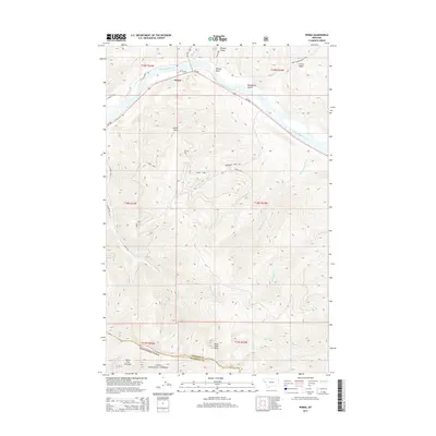
2014 Map of Perma
USGS Topo · Published 2014About this map
The Flathead River defines the northern reaches of this landscape, flowing past the settlement of Perma and beneath the overlook of Perma Point. This area of Western Montana is characterized by sharp elevational changes, where the river valley gives way to the high ridges of the Lolo National Forest. The map shows a complex network of drainage systems, including Seepay Cr and Vanderburg Cr, which carve through the terrain south of the river. To the east, the Ferry Basin and Racehorse Gulch suggest the historical pathways through this geography. Significant high points like Three Lakes Peak and Burnt Fork Pinnacle mark the southern boundary along the Sanders and Missoula County line, offering a detailed perspective on the region's wilderness and forest management roads.
Find a feature on this map
35 named features on this map. Tap any name to fly to it.
Don’t see what you’re looking for? This feature index may not catch every label — zoom into the map to look around manually.
Map Details
Editions of this 2014 Perma Map
This is the sole edition of this map. No revisions or reprints were ever made.
Other maps of this area

1956 · Wallace
USGS Topo · 1:250,000

1959 · Tarkio
USGS Topo · 1:62,500

1959 · Alberton
USGS Topo · 1:62,500

1959 · Perma
USGS Topo · 1:62,500

1960 · Wallace
USGS Topo · 1:250,000

1964 · Mc Donald
USGS Topo · 1:24,000

1964 · Melton Ranch
USGS Topo · 1:24,000

1983 · Horsehead Peak
USGS Topo · 1:24,000

1984 · Stark North
USGS Topo · 1:24,000
1984 · Mc Cormick Peak
USGS Topo · 1:24,000