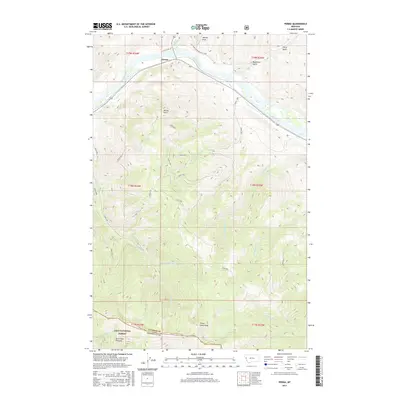
2017 Map of Perma
USGS Topo · Published 2017About this map
Perma sits along the northern banks of the Flathead River, serving as a focal point for this mountain landscape where Sanders Co and Missoula Co meet. The terrain is defined by dramatic elevation changes, rising from the river valley to prominent heights like Perma Point and the high southern ridgelines of the Lolo National Forest. Significant drainages including Camas Cr, Magpie Cr, and Seepay Cr carve through the steep slopes, while named landmarks like Three Lakes Peak and Burnt Fork Pinnacle dominate the southern skyline. A complex network of forest access roads, such as Dixon 5000 and Dixon 1000, provides the primary infrastructure through the heavily timbered sections of the forest. The map also captures several topographical features with local historical resonance, such as Ferry Basin, Wilcox Draw, and Racehorse Gulch, illustrating the traditional movement patterns through these mountain passes.
Find a feature on this map
35 named features on this map. Tap any name to fly to it.
Don’t see what you’re looking for? This feature index may not catch every label — zoom into the map to look around manually.
Map Details
Editions of this 2017 Perma Map
This is the sole edition of this map. No revisions or reprints were ever made.
Other maps of this area

1956 · Wallace
USGS Topo · 1:250,000

1959 · Tarkio
USGS Topo · 1:62,500

1959 · Alberton
USGS Topo · 1:62,500

1959 · Perma
USGS Topo · 1:62,500

1960 · Wallace
USGS Topo · 1:250,000

1964 · Mc Donald
USGS Topo · 1:24,000

1964 · Melton Ranch
USGS Topo · 1:24,000

1983 · Horsehead Peak
USGS Topo · 1:24,000

1984 · Stark North
USGS Topo · 1:24,000
1984 · Mc Cormick Peak
USGS Topo · 1:24,000