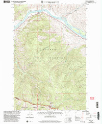
1999 Map of Perma
USGS Topo · Published 2003About this map
The Flathead River carves a significant course through the northern portion of this landscape, marking the boundary for the Flathead Indian Reservation. At the settlement of Perma, the river landscape is defined by the proximity of the rail line and the historic Ferry crossing near Racehorse, illustrating the vital transport corridors of the late 20th century. The terrain rises sharply from the riverbanks toward Perma Point and the high ridges of the Lolo National Forest to the south.
Find a feature on this map
25 named features on this map. Tap any name to fly to it.
Don’t see what you’re looking for? This feature index may not catch every label — zoom into the map to look around manually.
Map Details
Editions of this 1999 Perma Map
This is the sole edition of this map. No revisions or reprints were ever made.
Other maps of this area

1956 · Wallace
USGS Topo · 1:250,000

1959 · Tarkio
USGS Topo · 1:62,500

1959 · Alberton
USGS Topo · 1:62,500

1959 · Perma
USGS Topo · 1:62,500

1960 · Wallace
USGS Topo · 1:250,000

1964 · Mc Donald
USGS Topo · 1:24,000

1964 · Melton Ranch
USGS Topo · 1:24,000

1983 · Horsehead Peak
USGS Topo · 1:24,000

1984 · Stark North
USGS Topo · 1:24,000
1984 · Mc Cormick Peak
USGS Topo · 1:24,000