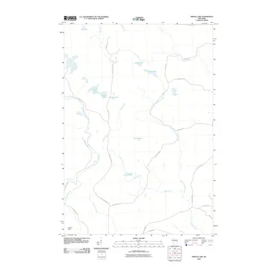
2010 Map of Perote Lake
USGS Topo · Published 2010About this map
Elton Creek and the West Branch Wolf River carve through this landscape of northern Wisconsin, which is defined by a dense network of glacial lakes and seasonal waterways. The drainage pattern is complex, with the Evergreen River cutting across the northeast corner while Squaw Creek and the Little West Branch Creek dominate the central terrain. The human footprint is largely defined by logging-era heritage, visible in the naming of roads like Camp 29 Rd and Camp 21 Rd, as well as the presence of the Dutchman Lookout Tower in the southwest corner. Significant named water bodies include Perote Lake, LaVerne Lake, and Teabeau Lake, which are connected by a web of rural routes such as the Bass Lake-Neopit Rd.
Find a feature on this map
31 named features on this map. Tap any name to fly to it.
Don’t see what you’re looking for? This feature index may not catch every label — zoom into the map to look around manually.
Map Details
Editions of this 2010 Perote Lake Map
This is the sole edition of this map. No revisions or reprints were ever made.
Other maps of this area

1952 · White Lake
USGS Topo · 1:48,000

1952 · Langlade
USGS Topo · 1:48,000

1954 · Gresham
USGS Topo · 1:48,000

1954 · Shawano
USGS Topo · 1:48,000

1954 · Iron Mountain
USGS Topo · 1:250,000

1955 · Green Bay
USGS Topo · 1:250,000

1959 · Iron Mountain
USGS Topo · 1:250,000

1964 · Shawano
USGS Topo · 1:62,500

1964 · Gresham
USGS Topo · 1:62,500
1973 · Langlade
USGS Topo · 1:24,000