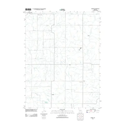
2012 Map of Perrin
USGS Topo · Published 2012About this map
Old Presbyterian Cemetery sits at the northern edge of this landscape, a quiet marker of early settlement patterns in DeKalb County. The terrain is defined by the branching tributaries of the Little Platte River and Castile Creek, creating a network of drainage ways that historically dictated the placement of small community hubs like Perrin and Braley. A notable localized landmark is the Eskin Post Office near Maple Hill, providing a specific point of interest for genealogists tracing postal routes and rural commerce.
Find a feature on this map
37 named features on this map. Tap any name to fly to it.
Don’t see what you’re looking for? This feature index may not catch every label — zoom into the map to look around manually.
Map Details
Editions of this 2012 Perrin Map
This is the sole edition of this map. No revisions or reprints were ever made.
Other maps of this area

1923 · Clarksdale
USGS Topo · 1:62,500

1923 · Maysville
USGS Topo · 1:62,500

1925 · Gower
USGS Topo · 1:62,500

1925 · Clarksdale
USGS Topo · 1:62,500

1925 · Plattsburg
USGS Topo · 1:62,500

1925 · Maysville
USGS Topo · 1:62,500

1950 · Kansas City
USGS Topo · 1:250,000
1951 · Gower
USGS Topo · 1:24,000

1954 · Kansas City
USGS Topo · 1:250,000

1956 · Kansas City
USGS Topo · 1:250,000