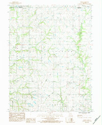
1984 Map of Perrin
USGS Topo · Published 1984About this map
Perrin sits at the heart of this mid-1980s landscape where the borders of Clinton and De Kalb counties meet. The area is defined by a dendritic drainage pattern led by the Platte River and Castile Creek, while the legacy of transportation is etched into the terrain through various rail lines. While the Burlington Northern route remains active in the northeast, several segments of Old Railroad Grade and Old Grade elsewhere suggest a shifting economic geography as earlier transit corridors were replaced or left behind.
Find a feature on this map
21 named features on this map. Tap any name to fly to it.
Don’t see what you’re looking for? This feature index may not catch every label — zoom into the map to look around manually.
Map Details
Editions of this 1984 Perrin Map
This is the sole edition of this map. No revisions or reprints were ever made.
Other maps of this area

1923 · Clarksdale
USGS Topo · 1:62,500

1923 · Maysville
USGS Topo · 1:62,500

1925 · Gower
USGS Topo · 1:62,500

1925 · Clarksdale
USGS Topo · 1:62,500

1925 · Plattsburg
USGS Topo · 1:62,500

1925 · Maysville
USGS Topo · 1:62,500

1950 · Kansas City
USGS Topo · 1:250,000
1951 · Gower
USGS Topo · 1:24,000

1954 · Kansas City
USGS Topo · 1:250,000

1956 · Kansas City
USGS Topo · 1:250,000