
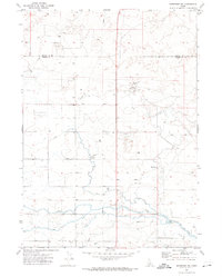
1964 Map of Perrine
USGS Topo · Published 1965About this map
Agricultural development in southern Jerome Co. is clearly defined in the mid-1960s by an intricate network of irrigation infrastructure. The North Side Main Canal and the D 5 Ditch dominate the landscape, supported by a Diversion Dam and the No 4 Pumping Station to move water through this arid region. The small settlement of Perrine serves as a central point along the Union Pacific railroad line, which cuts diagonally across the terrain, providing a vital link for local transport and commerce. Scattered throughout the quadrangle are several Gravel Pits and numerous Wells, indicating the ongoing extraction of local resources and the heavy reliance on groundwater to supplement the canal system. This map captures a specific stage of Idaho's reclamation history, where rail and water engineered the transition of the desert into productive land.
Find a feature on this map
17 named features on this map. Tap any name to fly to it.
Don’t see what you’re looking for? This feature index may not catch every label — zoom into the map to look around manually.
Map Details
Editions of this 1964 Perrine Map
This is the sole edition of this map. No revisions or reprints were ever made.
Other maps of this area

1955 · Twin Falls
USGS Topo · 1:250,000

1958 · Twin Falls
USGS Topo · 1:250,000

1964 · Kimberly
USGS Topo · 1:24,000

1964 · Falls City
USGS Topo · 1:24,000

1964 · Twin Falls
USGS Topo · 1:24,000

1964 · Eden
USGS Topo · 1:24,000

1964 · Hunt
USGS Topo · 1:24,000

1971 · Shoshone SE
USGS Topo · 1:24,000

1971 · Star Lake
USGS Topo · 1:24,000
1971 · Shoshone SW
USGS Topo · 1:24,000