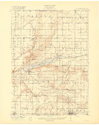
1918 Map of Perrinton
USGS Topo · Published 1918About this map
Maple River winds through the heart of this agricultural region during the early twentieth century, defining the border between Gratiot and Clinton counties. This 1918 edition illustrates a landscape of established townships like Fulton and North Star, where the rural economy was supported by a dense network of one-room schoolhouses such as Wermuth School and Belding School. The era's transportation infrastructure is clearly visible, with the Ann Arbor RR and Grand Trunk RR serving central hubs like Perrinton and Middleton.
Find a feature on this map
97 named features on this map. Tap any name to fly to it.
Don’t see what you’re looking for? This feature index may not catch every label — zoom into the map to look around manually.
Map Details
Editions of this 1918 Perrinton Map
2 editions found
Other maps of this area

1918 · Elsie
USGS Topo · 1:62,500

1918 · Perrinton
USGS Topo · 1:62,500

1927 · De Witt
USGS Topo · 1:62,500

1928 · Laingsburg
USGS Topo · 1:62,500

1934 · Merrill
USGS Topo · 1:62,500

1935 · Alma
USGS Topo · 1:62,500

1937 · Merrill
USGS Topo · 1:62,500

1938 · Alma
USGS Topo · 1:62,500

1943 · Perrinton
USGS Topo · 1:62,500

1943 · Elsie
USGS Topo · 1:62,500