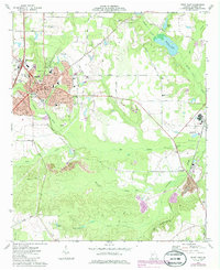
1973 Map of Perry East
USGS Topo · Published 1986About this map
Perry serves as the primary hub of this Houston County landscape, where the confluence of several key waterways like Big Indian Creek and Southern Creek dictates the local geography. The map reveals a mix of civic infrastructure and rural industry, featuring the County Correctional Institute and the Pabst settlement along the Southern railroad line. To the east, the landscape transitions into a series of water bodies including Houston Lake, Mossy Lake, and Kersey Lake, reflecting the region's complex drainage system. Genealogy interests are well-served by the documentation of Evergreen Cem, Laidler Cem, and the Perry Memorial Gardens, alongside historic educational sites such as New Hope Sch and Kings Chapel Sch. Further south, the industrial imprint of a large Quarry near Clinchfield highlights the area's geological utility during the early 1970s.
Find a feature on this map
74 named features on this map. Tap any name to fly to it.
Don’t see what you’re looking for? This feature index may not catch every label — zoom into the map to look around manually.
Map Details
Editions of this 1973 Perry East Map
2 editions found
Other maps of this area

1956 · Fort Valley
USGS Topo · 1:62,500

1956 · Perry
USGS Topo · 1:62,500

1956 · Warner Robins
USGS Topo · 1:62,500

1957 · Macon
USGS Topo · 1:250,000

1958 · Macon
USGS Topo · 1:250,000

1964 · Macon
USGS Topo · 1:250,000

1971 · Henderson
USGS Topo · 1:24,000

1972 · Perry West
USGS Topo · 1:24,000

1973 · Hayneville
USGS Topo · 1:24,000

1973 · Klondike
USGS Topo · 1:24,000