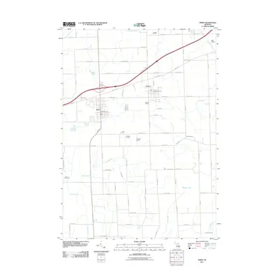
2011 Map of Perry
USGS Topo · Published 2011About this map
Perry and Morrice serve as the primary hubs of this landscape, situated along a network of rural roads and the Interstate corridor that crosses the northern half of the quadrangle. The agricultural and residential character of the area is punctuated by numerous community landmarks that speak to the local history and genealogy of the region. Scattered throughout the townships are several burial grounds, including Howard Cemetery in the north and Beard Cemetery in the east, while Roselawn Cemetery and Perry Cemetery are found south of the main Perry settlement. The drainage of the land is defined by the Looking Glass River and its various tributaries such as Grub Creek and Buck Branch. Notable local infrastructure includes the Dysinger Airport and Glenbrier Golf Course, reflecting the development of leisure and transit facilities amidst the traditional farmsteads and rural routes like Britton Rd and Winegar Rd.
Find a feature on this map
68 named features on this map. Tap any name to fly to it.
Don’t see what you’re looking for? This feature index may not catch every label — zoom into the map to look around manually.
Map Details
Editions of this 2011 Perry Map
This is the sole edition of this map. No revisions or reprints were ever made.
Other maps of this area

1908 · Fowlerville
USGS Topo · 1:62,500

1909 · Mason
USGS Topo · 1:62,500

1910 · Fowlerville
USGS Topo · 1:62,500

1911 · Mason
USGS Topo · 1:62,500

1926 · Corunna
USGS Topo · 1:62,500

1928 · Laingsburg
USGS Topo · 1:62,500

1929 · Corunna
USGS Topo · 1:62,500

1944 · Laingsburg
USGS Topo · 1:62,500

1944 · Corunna
USGS Topo · 1:62,500

1958 · Grand Rapids
USGS Topo · 1:250,000