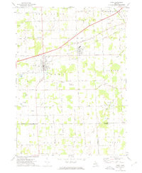
1972 Map of Perry
USGS Topo · Published 1975About this map
The Perry and Morrice communities center this 1970s landscape at the junction of Shiawassee, Ingham, and Livingston counties. The Grand Trunk Western railroad forms a sharp diagonal through the area, anchoring the industrial and transport identity of these small Michigan towns. Away from the rail corridor, the terrain is defined by the winding course of the Looking Glass River and several glacial depressions that hold Hemingway Lake, Bacon Lake, and Ward Lake. Local history is preserved in small rural burial grounds like Roselawn Cem and Beard Cem, while the Dysinger Landing Strip indicates the presence of private aviation in the mid-century agricultural landscape. Numerous gravel pits scattered near Perry suggest a localized extraction economy supporting the regional road network.
Find a feature on this map
63 named features on this map. Tap any name to fly to it.
Don’t see what you’re looking for? This feature index may not catch every label — zoom into the map to look around manually.
Map Details
Editions of this 1972 Perry Map
This is the sole edition of this map. No revisions or reprints were ever made.
Other maps of this area

1908 · Fowlerville
USGS Topo · 1:62,500

1909 · Mason
USGS Topo · 1:62,500

1910 · Fowlerville
USGS Topo · 1:62,500

1911 · Mason
USGS Topo · 1:62,500

1926 · Corunna
USGS Topo · 1:62,500

1928 · Laingsburg
USGS Topo · 1:62,500

1929 · Corunna
USGS Topo · 1:62,500

1944 · Laingsburg
USGS Topo · 1:62,500

1944 · Corunna
USGS Topo · 1:62,500

1958 · Grand Rapids
USGS Topo · 1:250,000