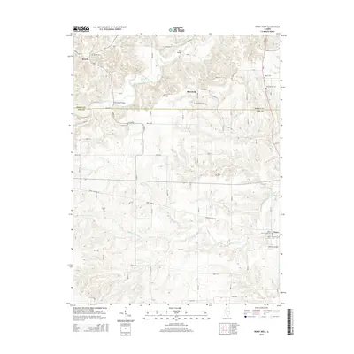
2015 Map of Perry West
USGS Topo · Published 2015About this map
Benville and Morrelville sit along the winding valley of McKee Creek on this 2015 study of the Illinois landscape. The map details a deeply etched drainage system where Middle Fork McKee Cr and Bower Cr carve through the terrain of Brown and Pike counties. For genealogists, the map is particularly dense with small family and community burial grounds, from the Seaborn Cem and Lutz Cem in the north to the clustered Wilson Cem and Perry-McCord Cem near the town of Perry. The road network follows the ridges and valleys, connecting landmarks like the Shinnebarger Bridge and Mountain Airport. This record of the mid-2010s shows a rural landscape where traditional small-town centers remain anchored by local institutions such as the Zion Lutheran Cem and Hebron Cem, reflecting generations of settlement in this part of the state.
Find a feature on this map
50 named features on this map. Tap any name to fly to it.
Don’t see what you’re looking for? This feature index may not catch every label — zoom into the map to look around manually.
Map Details
Editions of this 2015 Perry West Map
This is the sole edition of this map. No revisions or reprints were ever made.
Other maps of this area

1924 · Griggsville
USGS Topo · 1:62,500

1926 · Griggsville
USGS Topo · 1:62,500

1926 · Pittsfield
USGS Topo · 1:62,500

1926 · Mt Sterling
USGS Topo · 1:62,500

1928 · Meredosia
USGS Topo · 1:62,500

1929 · Mt Sterling
USGS Topo · 1:62,500

1931 · Meredosia
USGS Topo · 1:62,500

1948 · Quincy
USGS Topo · 1:250,000

1956 · Quincy
USGS Topo · 1:250,000
1980 · Perry East
USGS Topo · 1:24,000