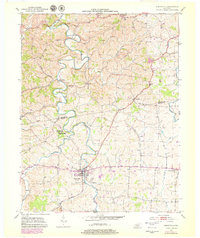
1952 Map of Perryville
USGS Topo · Published 1979About this map
Perryville Battlefield State Park preserves the grounds of one of Kentucky's most significant Civil War encounters, featuring the Perryville National Cemetery along the banks of the Chaplin River. This 1952 survey, with revisions from 1976, captures the intersection of commemorative grounds and active rural life in Boyle and Mercer counties. The landscape is defined by the winding paths of the Salt River and Doctors Fork, which dictate the placement of small settlements like Dixville and Nevada. Researchers can find several local landmarks such as Rose Hill High Sch and Black Sch, along with family and community burial grounds including Carpenter Cem and St Nicholas Cem. The inclusion of the Todd Crawford Trail provides a detailed look at the local thoroughfares connecting these agricultural communities during the mid-to-late 20th century.
Find a feature on this map
30 named features on this map. Tap any name to fly to it.
Don’t see what you’re looking for? This feature index may not catch every label — zoom into the map to look around manually.
Map Details
Editions of this 1952 Perryville Map
2 editions found
Other maps of this area

1905 · Harrodsburg
USGS Topo · 1:125,000

1952 · Perryville
USGS Topo · 1:24,000

1952 · Danville
USGS Topo · 1:24,000

1952 · Harrodsburg
USGS Topo · 1:24,000

1952 · Cornishville
USGS Topo · 1:24,000

1952 · Junction City
USGS Topo · 1:24,000

1952 · Parksville
USGS Topo · 1:24,000

1953 · Mackville
USGS Topo · 1:24,000

1953 · Gravel Switch
USGS Topo · 1:24,000

1953 · Cardwell
USGS Topo · 1:24,000