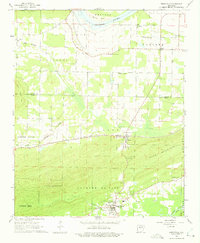
1961 Map of Perryville
USGS Topo · Published 1975About this map
The Fourche La Fave River and the Arkansas River define this corner of Perry County, where the lowlands meet the rising topography of Petit Jean and Perry Mountain. In the early 1960s, the county seat of Perryville served as the primary hub, while the Chicago Rock Island and Pacific railroad anchored the smaller settlement of Perry. The landscape is a mix of agricultural river bends like Willow Bend and significant relief, punctuated by landmarks such as Fourche Pinnacle.
Find a feature on this map
47 named features on this map. Tap any name to fly to it.
Don’t see what you’re looking for? This feature index may not catch every label — zoom into the map to look around manually.
Map Details
Editions of this 1961 Perryville Map
3 editions found
Other maps of this area

1889 · Morrilton No. 3
USGS Topo · 1:62,500

1890 · Benton
USGS Topo · 1:125,000

1892 · Morrillton
USGS Topo · 1:125,000

1894 · Morrillton
USGS Topo · 1:125,000

1894 · Benton
USGS Topo · 1:125,000

1955 · Little Rock
USGS Topo · 1:250,000

1956 · Little Rock
USGS Topo · 1:250,000

1956 · Russellville
USGS Topo · 1:250,000

1960 · Little Rock
USGS Topo · 1:250,000

1961 · Perryville
USGS Topo · 1:24,000