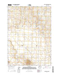
2014 Map of Peters Creek Sink
USGS Topo · Published 2014About this map
Peters Creek Sink and the vast Sage Plains characterize this arid high-desert landscape in Lake County. The drainage patterns of Peters Cr terminate in the seasonally dry Peters Lake, a distinctive endorheic basin typical of the Oregon outback. Human presence is marked by a network of ranching and utility roads, including the Christmas Valley Back Country Bywy and Millican Rd, which traverse the wide township lines. Rising above the flat plains, Bunchgrass Butte serves as a primary topographic landmark in an area defined by its geological depressions and expansive cattle-country range. This 2014 survey illustrates the modern configuration of access roads like Frederick Butte Rd and Stonehouse Rd, providing a clear view of the rural infrastructure supporting the remote interior of the state.
Find a feature on this map
21 named features on this map. Tap any name to fly to it.
Don’t see what you’re looking for? This feature index may not catch every label — zoom into the map to look around manually.
Map Details
Editions of this 2014 Peters Creek Sink Map
This is the sole edition of this map. No revisions or reprints were ever made.
Other maps of this area

1955 · Crescent
USGS Topo · 1:250,000

1957 · Crescent
USGS Topo · 1:250,000

1958 · Crescent
USGS Topo · 1:250,000

1970 · Crescent
USGS Topo · 1:250,000

1981 · Fossil Lake
USGS Topo · 1:24,000

1981 · Mean Rock Well
USGS Topo · 1:24,000

1982 · Peters Creek Sink
USGS Topo · 1:24,000

1982 · Christmas Lake
USGS Topo · 1:24,000

1982 · Jacks Place
USGS Topo · 1:24,000
1983 · Crack-in-the-Ground
USGS Topo · 1:24,000