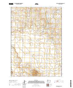
2020 Map of Peters Creek Sink
USGS Topo · Published 2020About this map
Sage Plains dominates this high-desert landscape in Lake County, where the topography reveals a quiet network of rural infrastructure and water management. Seasonal hydrology is central to the area, evidenced by the presence of Painters Reservoir in the north and Peters Lake further south, both connected by the drainage of Peters Cr. The land is defined by large-scale ranching or agricultural divisions, with long stretches of road such as Stone House Rd and Sagewood Ln cutting through the scrubland.
Find a feature on this map
27 named features on this map. Tap any name to fly to it.
Don’t see what you’re looking for? This feature index may not catch every label — zoom into the map to look around manually.
Map Details
Editions of this 2020 Peters Creek Sink Map
This is the sole edition of this map. No revisions or reprints were ever made.
Other maps of this area

1955 · Crescent
USGS Topo · 1:250,000

1957 · Crescent
USGS Topo · 1:250,000

1958 · Crescent
USGS Topo · 1:250,000

1970 · Crescent
USGS Topo · 1:250,000

1981 · Fossil Lake
USGS Topo · 1:24,000

1981 · Mean Rock Well
USGS Topo · 1:24,000

1982 · Peters Creek Sink
USGS Topo · 1:24,000

1982 · Christmas Lake
USGS Topo · 1:24,000

1982 · Jacks Place
USGS Topo · 1:24,000
1983 · Crack-in-the-Ground
USGS Topo · 1:24,000