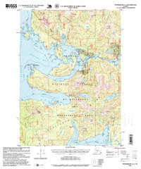
1995 Map of Petersburg A-5
USGS Topo · Published 1999About this map
Prince of Wales Island and Kosciusko Island anchor this coastal survey, where the intricate waterways of Shakan Bay and Davidson Inlet meet the Sumner Strait. The map reveals a landscape defined by maritime navigation and extractive history, most notably at the Shakan Light Station Island Lighthouse Reserve and the former settlement at Calder. A nearby quarry and log transfer facilities suggest the mid-1990s industrial footprint within the Tongass National Forest. Inland, the topography rises sharply to summits like Mount Calder and the twin peaks of The Nipples. On the eastern edge, El Capitan Lake sits tucked behind Dry Pass, while the southern reaches are dominated by the Mt Holbrook LUD II Management Area, centered on the peaks of Holbrook Mountain and the former Holbrook site.
Find a feature on this map
40 named features on this map. Tap any name to fly to it.
Don’t see what you’re looking for? This feature index may not catch every label — zoom into the map to look around manually.
Map Details
Editions of this 1995 Petersburg A-5 Map
This is the sole edition of this map. No revisions or reprints were ever made.
Other maps of this area

1948 · Petersburg A-6
USGS Topo · 1:63,360

1948 · Petersburg B-6
USGS Topo · 1:63,360

1949 · Petersburg B-5
USGS Topo · 1:63,360

1949 · Craig D-4
USGS Topo · 1:63,360

1949 · Petersburg A-5
USGS Topo · 1:63,360

1949 · Petersburg A-4
USGS Topo · 1:63,360

1949 · Petersburg B-4
USGS Topo · 1:63,360

1951 · Craig D-6
USGS Topo · 1:63,360

1951 · Craig D-5
USGS Topo · 1:63,360

1951 · Craig D-4
USGS Topo · 1:63,360