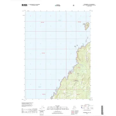
2017 Map of Petersburg A-6 SE
USGS Topo · Published 2017About this map
Kosciusko Island dominates the eastern shoreline on this coastal map, where the managed timberlands of the Tongass National Forest meet the North Pacific. The landscape is marked by unique geographical designations like the Trout Creek Grassland and the prominent Two Tipped Hill. Along the coast, maritime hazards and landmarks include the Pies Rock Reef and the Finger Shoal, while the interior is navigated via a network of forest service roads like the Shipley Bay 1530000 Road. Notable hydrologic features such as Charley Cr and a specifically labeled Disappearing Stream indicate the complex drainage patterns of this temperate rainforest environment. Near the southern edge of the sheet, Cape Pole serves as a significant coastal marker for the entrance to the surrounding waterways.
Find a feature on this map
26 named features on this map. Tap any name to fly to it.
Don’t see what you’re looking for? This feature index may not catch every label — zoom into the map to look around manually.
Map Details
Editions of this 2017 Petersburg A-6 SE Map
This is the sole edition of this map. No revisions or reprints were ever made.
Other maps of this area

1948 · Petersburg A-6
USGS Topo · 1:63,360

1949 · Petersburg A-5
USGS Topo · 1:63,360

1951 · Craig D-6
USGS Topo · 1:63,360

1951 · Craig D-5
USGS Topo · 1:63,360

1951 · Petersburg A-6
USGS Topo · 1:63,360

1952 · Petersburg
USGS Topo · 1:250,000

1953 · Petersburg A-5
USGS Topo · 1:63,360

1957 · Craig
USGS Topo · 1:250,000

1960 · Petersburg
USGS Topo · 1:250,000
1995 · Petersburg A-5
USGS Topo · 1:63,360