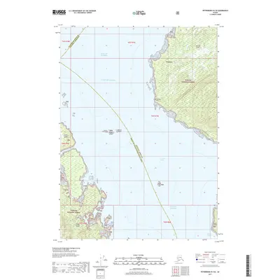
2017 Map of Petersburg B-4 SE
USGS Topo · Published 2017About this map
Tongass National Forest dominates the landmasses of this coastal Alaskan landscape, where the waters of the Clarence Strait meet the open Gulf of Alaska. The map highlights a significant maritime crossroads, marking the intersection of the Petersburg Borough, Wrangell Borough, and Prince of Wales-Hyder Census Area. The rugged shoreline of Zarembo Island is clearly defined by landmarks such as Wrangell and Macnamara Point, while smaller outcrops like the Rookery Islands, Round Island, and Tide Island dot the marine passages. Navigational features including the Ossipee Channel near Bushy Island provide essential context for understanding the historic and modern waterways used by local fishing and transport vessels. To the west, the eastern edge of Prince of Wales Island anchors the coastal survey, illustrating the complex island-and-strait geography of the Alexander Archipelago.
Find a feature on this map
15 named features on this map. Tap any name to fly to it.
Don’t see what you’re looking for? This feature index may not catch every label — zoom into the map to look around manually.
Map Details
Editions of this 2017 Petersburg B-4 SE Map
This is the sole edition of this map. No revisions or reprints were ever made.
Other maps of this area

1948 · Petersburg B-3
USGS Topo · 1:63,360

1949 · Petersburg A-3
USGS Topo · 1:63,360

1949 · Petersburg A-4
USGS Topo · 1:63,360

1949 · Petersburg B-4
USGS Topo · 1:63,360

1951 · Petersburg B-4
USGS Topo · 1:63,360

1951 · Petersburg B-3
USGS Topo · 1:63,360

1952 · Petersburg
USGS Topo · 1:250,000

1953 · Petersburg A-4
USGS Topo · 1:63,360

1953 · Petersburg A-3
USGS Topo · 1:63,360

1960 · Petersburg
USGS Topo · 1:250,000