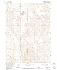
1963 Map of Petersburg
USGS Topo · Published 1985About this map
Petersburg sits atop the high ground of the Nebraska plains in this early 1960s landscape, serving as a hub for the surrounding agricultural district of Boone County. The town is defined by a grid of streets and numerous wells, while the Old Railroad Grade provides a clear record of the transportation infrastructure that once connected these rural communities. To the south, the village of Loretto marks a smaller node of settlement near a Gaging Station and the bend of Beaver Creek.
Find a feature on this map
12 named features on this map. Tap any name to fly to it.
Don’t see what you’re looking for? This feature index may not catch every label — zoom into the map to look around manually.
Map Details
Editions of this 1963 Petersburg Map
2 editions found
Other maps of this area

1954 · Akron
USGS Topo · 1:24,000

1954 · Albion West
USGS Topo · 1:24,000

1955 · Broken Bow
USGS Topo · 1:250,000

1955 · Fremont
USGS Topo · 1:250,000

1956 · Broken Bow
USGS Topo · 1:250,000

1957 · Fremont
USGS Topo · 1:250,000

1958 · Fremont
USGS Topo · 1:250,000

1958 · Albion East
USGS Topo · 1:24,000

1963 · Petersburg
USGS Topo · 1:24,000

1963 · Closter SW
USGS Topo · 1:24,000