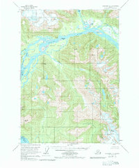
1953 Map of Petersburg C-1
USGS Topo · Published 1983About this map
The Stikine River delta dominates this mid-century survey, revealing a dynamic landscape of braided channels and shifting sediment deposits. In this era before widespread development, the map documents the intricate network of the Shakes Slough and Ketili River as they weave around Andrew Island and the Cottonwood Islands. The presence of the Chief Shakes Hot Springs near the river's northern bend highlights a significant natural landmark of the region.
Find a feature on this map
37 named features on this map. Tap any name to fly to it.
Don’t see what you’re looking for? This feature index may not catch every label — zoom into the map to look around manually.
Map Details
Editions of this 1953 Petersburg C-1 Map
3 editions found
Other maps of this area

1948 · Petersburg C-1
USGS Topo · 1:63,360

1948 · Petersburg C-2
USGS Topo · 1:63,360

1948 · Petersburg B-2
USGS Topo · 1:63,360

1948 · Petersburg B-1
USGS Topo · 1:63,360

1951 · Bradfield Canal
USGS Topo · 1:250,000

1951 · Petersburg C-2
USGS Topo · 1:63,360

1952 · Petersburg
USGS Topo · 1:250,000

1953 · Petersburg C-1
USGS Topo · 1:63,360

1953 · Petersburg B-2
USGS Topo · 1:63,360

1954 · Bradfield Canal
USGS Topo · 1:250,000