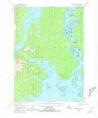
1948 Map of Petersburg C-6
USGS Topo · Published 1981About this map
Kuiu Island and Kupreanof Island dominate this topographic study, separated by the intricate maritime corridor of Rocky Pass. This 1948 survey, based on aerial photography, documents the complex shoreline of the Tongass National Forest before modern developments. The geography is defined by narrow waterways and sheltered inlets like Seclusion Harbor and Salt Lagoon, which suggest the historical reliance on small-craft navigation for accessing the interior of these islands. The presence of named maritime hazards and landmarks such as Devils Elbow and The Summit highlights the essential nature of coastal piloting in the Alexander Archipelago. Farther south, the expanse of Three Mile Arm and the isolated Monte Carlo Island illustrate a landscape of dense timber and tidal flats, largely untouched by road networks or permanent settlements during the mid-century era.
Find a feature on this map
22 named features on this map. Tap any name to fly to it.
Don’t see what you’re looking for? This feature index may not catch every label — zoom into the map to look around manually.
Map Details
Editions of this 1948 Petersburg C-6 Map
4 editions found
Other maps of this area

1948 · Port Alexander C-1
USGS Topo · 1:63,360

1948 · Petersburg B-6
USGS Topo · 1:63,360

1948 · Port Alexander B-1
USGS Topo · 1:63,360

1948 · Petersburg D-6
USGS Topo · 1:63,360

1948 · Port Alexander D-1
USGS Topo · 1:63,360

1948 · Petersburg C-6
USGS Topo · 1:63,360

1948 · Petersburg C-5
USGS Topo · 1:63,360

1948 · Petersburg D-5
USGS Topo · 1:63,360

1949 · Petersburg B-5
USGS Topo · 1:63,360

1951 · Port Alexander
USGS Topo · 1:250,000