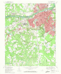
1969 Map of Petersburg
USGS Topo · Published 1971About this map
Petersburg and Colonial Heights dominate this late-1960s landscape, where urban density meets the sprawling preservation of the Petersburg National Military Park. The map documents a complex overlay of 19th-century history and mid-20th-century development, showing the transition from the industrial corridors of the Appomattox River to the expanding residential neighborhoods of Walnut Hill and Ettrick. On Pocahontas Island and throughout the city, the grid reflects a deeply layered settlement history, while the surrounding countryside is marked by numerous Civil War fortifications such as Fort Fisher and Fort Wadsworth.
Find a feature on this map
49 named features on this map. Tap any name to fly to it.
Don’t see what you’re looking for? This feature index may not catch every label — zoom into the map to look around manually.
Map Details
Editions of this 1969 Petersburg Map
Other maps of this area

1894 · Bermuda Hundred
USGS Topo · 1:62,500

1894 · Petersburg
USGS Topo · 1:62,500

1897 · Amelia
USGS Topo · 1:125,000

1943 · Hopewell
USGS Topo · 1:31,680

1943 · Dinwiddie
USGS Topo · 1:24,000

1943 · Beach
USGS Topo · 1:24,000

1943 · Sutherland
USGS Topo · 1:24,000

1943 · Richmond
USGS Topo · 1:250,000
1944 · Beach
USGS Topo · 1:31,680

1944 · Reams
USGS Topo · 1:31,680