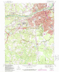
1969 Map of Petersburg
USGS Topo · Published 1987About this map
The city of Petersburg and the winding Appomattox River anchor this late-1960s survey, capturing a landscape deeply defined by its Civil War heritage and mid-century expansion. The map provides an intricate view of the Petersburg Nat Battlefield, documenting the spatial relationship between residential growth in neighborhoods like Walnut Hill and historic earthworks such as The Crater and Fort Lee. Beyond the urban core, the terrain transitions into the swampy bottomlands of Arthur Swamp and Reedy Branch, where the Poplar Grove National Cem and rural landmarks like St Johns Ch remain preserved among the encroaching suburbs. Significant institutional footprints are visible at the Central State Hospital and Virginia State University, while the rail corridors of the Norfolk and Western and Seaboard Coast Line continue to shape the regional industrial geography.
Find a feature on this map
58 named features on this map. Tap any name to fly to it.
Don’t see what you’re looking for? This feature index may not catch every label — zoom into the map to look around manually.
Map Details
Editions of this 1969 Petersburg Map
Other maps of this area

1894 · Bermuda Hundred
USGS Topo · 1:62,500

1894 · Petersburg
USGS Topo · 1:62,500

1897 · Amelia
USGS Topo · 1:125,000

1943 · Hopewell
USGS Topo · 1:31,680

1943 · Dinwiddie
USGS Topo · 1:24,000

1943 · Beach
USGS Topo · 1:24,000

1943 · Sutherland
USGS Topo · 1:24,000

1943 · Richmond
USGS Topo · 1:250,000
1944 · Beach
USGS Topo · 1:31,680

1944 · Reams
USGS Topo · 1:31,680