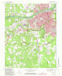
1969 Map of Petersburg
USGS Topo · Published 1982About this map
The Appomattox River serves as the central artery for this late 1960s study, dividing the industrial and residential centers of Petersburg and Colonial Heights. The map documents a landscape defined by its Civil War heritage, with extensive defensive works including Fort Lee, Fort Fisher, and The Crater preserved within the Petersburg National Battlefield. These military earthworks sit in contrast to the rapid mid-century expansion visible in neighborhoods like Walnut Hill and Kennelworth.
Find a feature on this map
66 named features on this map. Tap any name to fly to it.
Don’t see what you’re looking for? This feature index may not catch every label — zoom into the map to look around manually.
Map Details
Editions of this 1969 Petersburg Map
Other maps of this area

1894 · Bermuda Hundred
USGS Topo · 1:62,500

1894 · Petersburg
USGS Topo · 1:62,500

1897 · Amelia
USGS Topo · 1:125,000

1943 · Hopewell
USGS Topo · 1:31,680

1943 · Dinwiddie
USGS Topo · 1:24,000

1943 · Beach
USGS Topo · 1:24,000

1943 · Sutherland
USGS Topo · 1:24,000

1943 · Richmond
USGS Topo · 1:250,000
1944 · Beach
USGS Topo · 1:31,680

1944 · Reams
USGS Topo · 1:31,680