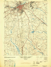
1946 Map of Petersburg
USGS Topo · Published 1946About this map
The Appomattox River anchors this 1946 study of the region, where the urban center of Petersburg meets a landscape still deeply defined by its military history and swampy terrain. Significant acreage is dedicated to the Petersburg National Military Park and Camp Lee Military Reservation, reflecting the area's strategic importance during the Civil War and the mid-century mobilization. To the south and west, the map details a rural network of small communities and crossroads like Reams and Rowanta, many centered around local schools such as the Rives School or historic meeting places like Providence Church. The rail infrastructure is particularly prominent, showing the convergence of the Norfolk and Western, Atlantic Coast Line, and Seaboard Air Line railroads. These lines parallel the primary transit routes of the era, including U.S. Hy. No. 1 and U.S. Hy. No. 301, which connect the industrializing city to the agrarian hinterlands of Dinwiddie and Prince George counties.
Find a feature on this map
70 named features on this map. Tap any name to fly to it.
Don’t see what you’re looking for? This feature index may not catch every label — zoom into the map to look around manually.
Map Details
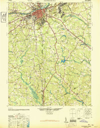
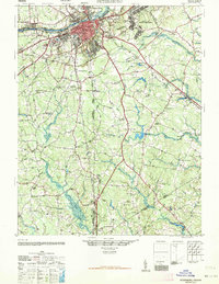
Editions of this 1946 Petersburg Map
3 editions found
Other maps of this area

1894 · Bermuda Hundred
USGS Topo · 1:62,500

1894 · Petersburg
USGS Topo · 1:62,500

1897 · Amelia
USGS Topo · 1:125,000

1918 · Charles City
USGS Topo · 1:62,500

1919 · Jarratt
USGS Topo · 1:62,500

1919 · Mc Kenney
USGS Topo · 1:48,000

1919 · Disputanta
USGS Topo · 1:62,500

1919 · Homeville
USGS Topo · 1:48,000

1920 · Homeville
USGS Topo · 1:62,500

1921 · Mc Kenney
USGS Topo · 1:62,500