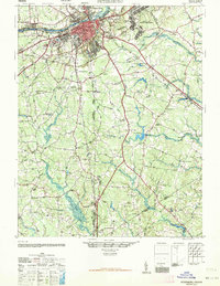
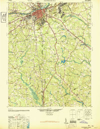
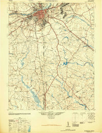
1946 Map of Petersburg
USGS Topo · Published 1964About this map
The Appomattox River anchors this postwar landscape, separating the dense urban core of Petersburg from Ettrick, Matoaca, and Colonial Heights to the north. Compiled just after the war, the map highlights the immense footprint of the Camp Lee Military Reservation and the sprawling Petersburg Battlefield Park that preserves the region's complex history. A network of three major railroads—the Norfolk and Western, Atlantic Coast Line, and Seaboard Air Line—converges on the city, illustrating its role as a vital mid-century transportation hub.
Find a feature on this map
80 named features on this map. Tap any name to fly to it.
Don’t see what you’re looking for? This feature index may not catch every label — zoom into the map to look around manually.
Map Details
Editions of this 1946 Petersburg Map
3 editions found
Other maps of this area

1894 · Bermuda Hundred
USGS Topo · 1:62,500

1894 · Petersburg
USGS Topo · 1:62,500

1897 · Amelia
USGS Topo · 1:125,000

1918 · Charles City
USGS Topo · 1:62,500

1919 · Jarratt
USGS Topo · 1:62,500

1919 · Mc Kenney
USGS Topo · 1:48,000

1919 · Disputanta
USGS Topo · 1:62,500

1919 · Homeville
USGS Topo · 1:48,000

1920 · Homeville
USGS Topo · 1:62,500

1921 · Mc Kenney
USGS Topo · 1:62,500