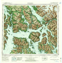
1952 Map of Petersburg
USGS Topo · Published 1957About this map
Kupreanof Island and the surrounding Alexander Archipelago dominate this early 1950s reconnaissance, which reveals the maritime settlement patterns of Southeast Alaska. The coastal communities of Petersburg, Wrangell, and Kake serve as established hubs, while smaller labels like Hamilton, Shakan, and the cannery site at Tonka indicate the region's reliance on the fishing and timber industries. The rugged geography is defined by deep waterways such as Sumner Strait and the Duncan Canal, alongside massive glaciated peaks like Castle Mtn and Thunder Mtn. Inside the Tongass National Forest, the map traces the intersection of the Stikine River with the coast, marking the international boundary between the First Judicial Division of Alaska and British Columbia. These survey details capture the territory just before statehood, documenting isolated points like Cemetery Pt and the seasonal settlements of West Petersburg and Doyhof.
Find a feature on this map
57 named features on this map. Tap any name to fly to it.
Don’t see what you’re looking for? This feature index may not catch every label — zoom into the map to look around manually.
Map Details
Editions of this 1952 Petersburg Map
5 editions found

Other maps of this area

1948 · Sumdum A-4
USGS Topo · 1:63,360

1948 · Port Alexander C-1
USGS Topo · 1:63,360

1948 · Petersburg A-6
USGS Topo · 1:63,360

1948 · Petersburg A-1
USGS Topo · 1:63,360

1948 · Petersburg A-2
USGS Topo · 1:63,360

1948 · Port Alexander A-1
USGS Topo · 1:63,360

1948 · Sumdum A-5
USGS Topo · 1:63,360

1948 · Petersburg C-4
USGS Topo · 1:63,360

1948 · Petersburg B-6
USGS Topo · 1:63,360

1948 · Petersburg C-1
USGS Topo · 1:63,360