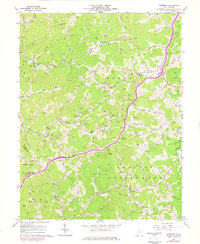
1966 Map of Peterson
USGS Topo · Published 1977About this map
Bealls Mills and Aspinall occupy the complex drainage network of the West Virginia highlands, where industrial activity and rural life meet. The landscape is defined by the headwaters of numerous runs and forks, such as Sand Fork and Indian Fork, which cut through the ridges of Courthouse and Collins Settlement districts. This mid-century survey reveals a territory undergoing transition, evidenced by the proliferation of gas wells and the presence of Strip Mines near Pine Knob and Poplarlick Run. For genealogists and local historians, the map preserves the exact locations of many family-oriented landmarks, including St Bernards Ch in the north and St Bridgets Ch along the Goosepen Run. Small rural communities like Bennett and Peterson are shown in their mid-century context, connected by winding valley roads that trace the natural contours of the hills.
Find a feature on this map
65 named features on this map. Tap any name to fly to it.
Don’t see what you’re looking for? This feature index may not catch every label — zoom into the map to look around manually.
Map Details
Editions of this 1966 Peterson Map
3 editions found
Other maps of this area

1893 · Buckhannon
USGS Topo · 1:125,000

1893 · Sutton
USGS Topo · 1:125,000

1896 · Buckhannon
USGS Topo · 1:125,000

1897 · Buckhannon
USGS Topo · 1:125,000

1904 · Weston
USGS Topo · 1:62,500

1904 · Vadis
USGS Topo · 1:62,500

1906 · Burnsville
USGS Topo · 1:62,500

1912 · Crawford
USGS Topo · 1:48,000

1914 · Crawford
USGS Topo · 1:62,500

1925 · Burnsville
USGS Topo · 1:62,500