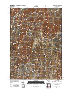
2011 Map of Peterson Point
USGS Topo · Published 2011About this map
Peterson Point and Black Mountain anchor this landscape in Crook County, where high-desert drainage patterns are defined by a network of seasonal and year-round water sources. The map reveals an intricate system of named springs, such as Dick Nickolas Spring, Woodchuck Spring, and Ernie Spring, which historically supported livestock and early land use in this arid region. The drainage is dominated by Indian Creek and Keeton Creek, while the Lonesome Spring Campground serves as a modern waypoint. The road network, including Peterson Creek Rd and Buck Point Rd, follows the natural contours of the ridges and canyons, illustrating how transportation routes were dictated by the complex local topography of central Oregon.
Find a feature on this map
44 named features on this map. Tap any name to fly to it.
Don’t see what you’re looking for? This feature index may not catch every label — zoom into the map to look around manually.
Map Details
Editions of this 2011 Peterson Point Map
This is the sole edition of this map. No revisions or reprints were ever made.
Other maps of this area

1926 · Mitchell
USGS Topo · 1:125,000

1932 · Dayville
USGS Topo · 1:125,000

1936 · Dayville
USGS Topo · 1:125,000

1953 · Richmond
USGS Topo · 1:62,500

1955 · Bend
USGS Topo · 1:250,000

1955 · Canyon City
USGS Topo · 1:250,000

1957 · Bend
USGS Topo · 1:250,000

1958 · Bend
USGS Topo · 1:250,000

1959 · Canyon City
USGS Topo · 1:250,000

1965 · Williams Prairie
USGS Topo · 1:24,000