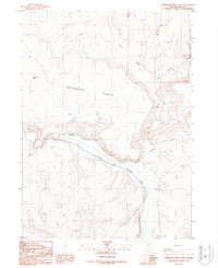
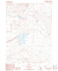
1987 Map of Peterson Table East
USGS Topo · Published 1987About this map
South Fork Owyhee River carves through the high plateau of Elko County, defining the drainage patterns of this arid landscape. This 1987 provisional map documents a transition between open range and the southwestern corner of the Duck Valley Indian Reservation. The prominent Peterson Table dominates the central terrain, bordered by a series of seasonal drainages including Circle Creek, Spring Creek, and Sheep Creek. Human intervention in this environment is marked by water management and resource extraction, evidenced by the Ditch system and a Road on Levee following the river's path. Scattered industrial and ranching landmarks like the Quarry and Four Mile Well point to the remote operations of the Great Basin, where limited water sources dictate the placement of roads and structures.
Find a feature on this map
14 named features on this map. Tap any name to fly to it.
Don’t see what you’re looking for? This feature index may not catch every label — zoom into the map to look around manually.
Map Details
Editions of this 1987 Peterson Table East Map
This is the sole edition of this map. No revisions or reprints were ever made.
Other maps of this area

1955 · McDermitt
USGS Topo · 1:250,000

1959 · McDermitt
USGS Topo · 1:250,000

1964 · Hat Peak
USGS Topo · 1:62,500

1964 · Wilson Reservoir
USGS Topo · 1:62,500
1974 · Twelvemile Flat SE
USGS Topo · 1:24,000

1974 · Desert Ranch
USGS Topo · 1:24,000
1977 · State Line Camp
USGS Topo · 1:24,000

1982 · Bull Run Mts
USGS Topo · 1:100,000
1987 · Fourmile Butte
USGS Topo · 1:24,000
1987 · Wilson Reservoir
USGS Topo · 1:24,000