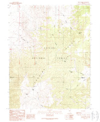
1989 Map of Petes Summit
USGS Topo · Published 1990About this map
Toiyabe National Forest encompasses this high-elevation landscape where the Toiyabe Range and Toquima Range meet. This survey shows a land defined by its mining prospects and water sources, essential for survival in the arid terrain of central Nevada. Evidence of early mineral exploration is visible at the Indian Blue Mine and Bronco Mine, along with various unnamed Prospect locations scattered through the canyons. The presence of Toquima Cave suggests a much older human history in the area, while the modern boundary between Lander and Nye counties cuts through the high ridges. Life in this remote stretch of the Great Basin centered on named water points like Petes Spring, Henry Meyer Spring, and Clipper Gap Spring, which provided relief for travelers and early settlers moving through Petes Summit and Clipper Gap.
Find a feature on this map
28 named features on this map. Tap any name to fly to it.
Don’t see what you’re looking for? This feature index may not catch every label — zoom into the map to look around manually.
Map Details
Editions of this 1989 Petes Summit Map
This is the sole edition of this map. No revisions or reprints were ever made.
Other maps of this area

1926 · Roberts Mountains
USGS Topo · 1:250,000

1929 · Roberts Mountains
USGS Topo · 1:250,000

1955 · Millett
USGS Topo · 1:250,000

1959 · Millett
USGS Topo · 1:250,000

1960 · Hickison Summit
USGS Topo · 1:62,500

1960 · Spencer Hot Springs
USGS Topo · 1:62,500

1960 · Dianas Punch Bowl
USGS Topo · 1:62,500

1960 · Wildcat Peak
USGS Topo · 1:62,500

1978 · Summit Mountain
USGS Topo · 1:100,000
1989 · Dianas Punch Bowl
USGS Topo · 1:24,000