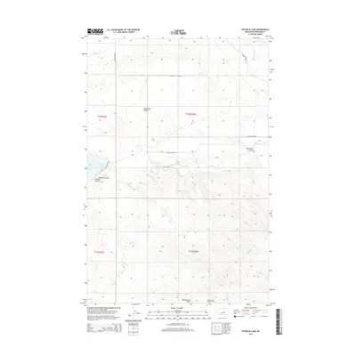
2014 Map of Petrolia Lake
USGS Topo · Published 2014About this map
Petrolia Lake and the surrounding drainage of Flatwillow Cr characterize this portion of Petroleum County, Montana. The landscape is marked by the industrial footprint of the Rattlesnake Butte Oil Field in the south, while the northern terrain is defined by a series of geographic coulees and creeks. Named ranch roads like Kiehl Ranch Rd and Petrolia Dam Rd crisscross the section lines, reflecting the rural and agricultural focus of the area. Distinctive landmarks such as Rattlesnake Butte and Racehorse Coulee provide orientation within this expanse of Central Montana. The map illustrates a region where water management and resource extraction are the primary drivers of land use, shown through the network of local connectors and named water bodies including McDonald Cr and Box Elder Cr.
Find a feature on this map
20 named features on this map. Tap any name to fly to it.
Don’t see what you’re looking for? This feature index may not catch every label — zoom into the map to look around manually.
Map Details
Editions of this 2014 Petrolia Lake Map
This is the sole edition of this map. No revisions or reprints were ever made.
Other maps of this area

1954 · Roundup
USGS Topo · 1:250,000

1954 · Lewistown
USGS Topo · 1:250,000

1958 · Roundup
USGS Topo · 1:250,000

1959 · Lewistown
USGS Topo · 1:250,000

1963 · Kelley
USGS Topo · 1:24,000

1963 · Petrolia Lake
USGS Topo · 1:24,000
1963 · Breed Spring
USGS Topo · 1:24,000
1963 · Mud Spring
USGS Topo · 1:24,000
1986 · Cat Creek
USGS Topo · 1:24,000

1986 · Ingals Dam
USGS Topo · 1:24,000