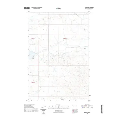
2020 Map of Petrolia Lake
USGS Topo · Published 2020About this map
Petrolia Lake dominates the western edge of this central Montana landscape, where the high plains meet a complex network of seasonal drainages. The topography is defined by significant coulees and ridges, including the deep-cut Johnson Coulee and the uniquely named Racehorse Coulee. These features illustrate the erosion patterns characteristic of Petroleum County, where waterways like Flatwillow Cr and McDonald Cr carve through the arid terrain.
Find a feature on this map
13 named features on this map. Tap any name to fly to it.
Don’t see what you’re looking for? This feature index may not catch every label — zoom into the map to look around manually.
Map Details
Editions of this 2020 Petrolia Lake Map
This is the sole edition of this map. No revisions or reprints were ever made.
Other maps of this area

1954 · Roundup
USGS Topo · 1:250,000

1954 · Lewistown
USGS Topo · 1:250,000

1958 · Roundup
USGS Topo · 1:250,000

1959 · Lewistown
USGS Topo · 1:250,000

1963 · Kelley
USGS Topo · 1:24,000

1963 · Petrolia Lake
USGS Topo · 1:24,000
1963 · Breed Spring
USGS Topo · 1:24,000
1963 · Mud Spring
USGS Topo · 1:24,000
1986 · Cat Creek
USGS Topo · 1:24,000

1986 · Ingals Dam
USGS Topo · 1:24,000