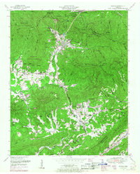
1952 Map of Petros
USGS Topo · Published 1967About this map
Brushy Mountain State Prison sits at the head of a narrow valley, surrounded by the high ridges of Morgan State Forest. This 1952 survey, updated with 1967 cultural revisions, documents a landscape defined by the steep Cumberland Plateau terrain and the industrial extraction of coal. The community of Petros serves as the focal point for the prison and local mining operations, while the Southern railroad line snakes through the valleys to reach Coalfield and Scandlyn. In the surrounding hills, numerous family burial grounds like Joe Goddard Cemetery, Langley Cemetery, and Brasel Cemetery offer significant genealogical value, often located near small rural institutions like the Joyner School and Beech Grove Church. The map's contour lines illustrate the dramatic elevation changes between peaks like Frozen Head Mountain and the deep hollows where Crooked Fork and Little Fork drain the plateau.
Find a feature on this map
95 named features on this map. Tap any name to fly to it.
Don’t see what you’re looking for? This feature index may not catch every label — zoom into the map to look around manually.
Map Details
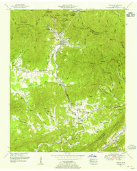
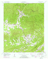
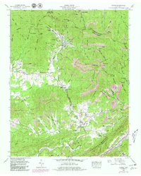
Editions of this 1952 Petros Map
4 editions found
Other maps of this area

1887 · Kingston
USGS Topo · 1:125,000

1891 · Kingston
USGS Topo · 1:125,000

1893 · Briceville
USGS Topo · 1:125,000

1893 · Kingston
USGS Topo · 1:125,000

1895 · Wartburg
USGS Topo · 1:125,000

1895 · Loudon
USGS Topo · 1:125,000

1895 · Briceville
USGS Topo · 1:125,000

1896 · Wartburg
USGS Topo · 1:125,000

1896 · Briceville
USGS Topo · 1:125,000

1935 · Gobey
USGS Topo · 1:24,000