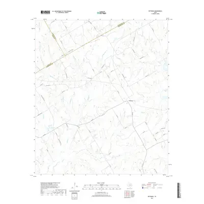
2019 Map of Petteway
USGS Topo · Published 2019About this map
Petteway serves as a central reference point in this rural landscape at the convergence of Falls, Limestone, and Robertson Counties. The terrain is defined by an intricate network of waterways, including Big Sandy Cr, Little Sandy Cr, and the winding Walnut Cr. These drainages create a rolling topography that shaped the local road network, which remains largely rural and unpaved. Notable landmarks for local history include Abraham Lake and the descriptive Walnut Cemetery Rd, reflecting the community's early settlement patterns. Several family-named or descriptive routes like Bar Z Ranch Rd and Viterra Rd indicate the area's ongoing agricultural and ranching character. The map illustrates how the physical geography of creeks like Beck Cr and Hurricane Cr dictated property boundaries and transport routes along the county lines.
Find a feature on this map
64 named features on this map. Tap any name to fly to it.
Don’t see what you’re looking for? This feature index may not catch every label — zoom into the map to look around manually.
Map Details
Editions of this 2019 Petteway Map
This is the sole edition of this map. No revisions or reprints were ever made.
Other maps of this area

1927 · Marquez
USGS Topo · 1:62,500

1930 · Marquez
USGS Topo · 1:62,500

1954 · Waco
USGS Topo · 1:250,000

1955 · Waco
USGS Topo · 1:250,000

1962 · Hammond
USGS Topo · 1:24,000

1962 · Bremond
USGS Topo · 1:24,000

1962 · Petteway
USGS Topo · 1:24,000
1962 · Owensville
USGS Topo · 1:24,000
1965 · Franklin
USGS Topo · 1:24,000
1965 · Bald Prairie
USGS Topo · 1:24,000