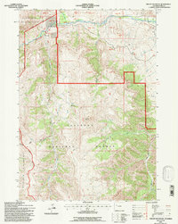
1991 Map of Phelps Mountain
USGS Topo · Published 1997About this map
High-altitude ranching and energy extraction intersect on this remote Wyoming landscape, where the Shoshone National Forest meets the protected reaches of the Washakie Wilderness. The terrain is dominated by the massif of Phelps Mountain, which serves as a literal divide between the deep drainages of Willow Creek and Bear Creek. To the north, the Greybull River cuts through a series of numbered land tracts, reflecting complex historical surveying and property divisions in this part of Park County.
Find a feature on this map
36 named features on this map. Tap any name to fly to it.
Don’t see what you’re looking for? This feature index may not catch every label — zoom into the map to look around manually.
Map Details
Editions of this 1991 Phelps Mountain Map
This is the sole edition of this map. No revisions or reprints were ever made.
Other maps of this area

1904 · Kirwin
USGS Topo · 1:125,000

1906 · Kirwin
USGS Topo · 1:125,000

1955 · Cody
USGS Topo · 1:250,000

1955 · Thermopolis
USGS Topo · 1:250,000

1957 · Irish Rock
USGS Topo · 1:62,500

1957 · Sunshine Reservoir
USGS Topo · 1:62,500

1958 · Cody
USGS Topo · 1:250,000

1958 · Thermopolis
USGS Topo · 1:250,000

1962 · Thermopolis
USGS Topo · 1:250,000

1962 · Cody
USGS Topo · 1:250,000