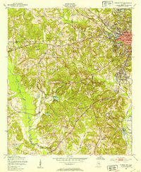
1950 Map of Phenix City
USGS Topo · Published 1954About this map
Phenix City and the surrounding borderlands of Lee and Russell counties are captured here at mid-century, reflecting a landscape defined by industrial pockets and numerous rural congregations. The northeastern corner shows the urban density of Girard and the city center, complete with Martin Stadium, Central High Sch, and Idle Hour Park. Further south and west, the terrain shifts into a network of small creeks like Cochgalechee Creek and Little Uchee Creek, where small settlements such as Ladonia, Kaolin, and the rail-oriented Brickyard sit along the Central of Georgia railroad line. The high density of country churches—including Uchee Hill Ch, Pine Grove Ch, and Mother Mary Mission—points to the deeply established rural communities and social centers that characterized this part of eastern Alabama before later suburban expansion.
Find a feature on this map
41 named features on this map. Tap any name to fly to it.
Don’t see what you’re looking for? This feature index may not catch every label — zoom into the map to look around manually.
Map Details
Editions of this 1950 Phenix City Map
2 editions found

Other maps of this area

1907 · Talbotton
USGS Topo · 1:125,000

1907 · Opelika
USGS Topo · 1:125,000

1908 · Columbus
USGS Topo · 1:62,500

1909 · Opelika
USGS Topo · 1:125,000

1914 · Seale
USGS Topo · 1:62,500

1929 · Columbus
USGS Topo · 1:48,000

1947 · Columbus
USGS Topo · 1:62,500

1949 · Fort Mitchell
USGS Topo · 1:24,000

1949 · Columbus
USGS Topo · 1:24,000

1950 · Fort Benning
USGS Topo · 1:24,000