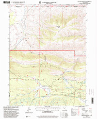
1996 Map of Phil Pico Mountain
USGS Topo · Published 2000About this map
Ashley National Forest dominates this high-altitude landscape along the border of Utah and Wyoming, where the dramatic peaks of Phil Pico Mountain and Corson Peak overlook a complex network of alpine hydrology. The map details an environment defined by the intersection of early military history and modern water management. The historical Carter Military Trail and the Carter Dugway wind through the terrain, tracing a path used for logistics during the region's territorial era. Below these ridges, the landscape opens into grazing and drainage areas like Hickerson Park and Sheep Creek Park. A series of infrastructure points, including the Lodgepole Canal Bridge and Sheep Creek Canal Bridge, illustrate the intricate effort to divert and manage water through the high country. These features, along with the Long Park Reservoir, highlight how this wilderness has been utilized for both transit and resource control within Daggett Co and Sweetwater Co.
Find a feature on this map
40 named features on this map. Tap any name to fly to it.
Don’t see what you’re looking for? This feature index may not catch every label — zoom into the map to look around manually.
Map Details
Editions of this 1996 Phil Pico Mountain Map
This is the sole edition of this map. No revisions or reprints were ever made.
Other maps of this area

1885 · Ashley
USGS Topo · 1:250,000

1885 · Uinta
USGS Topo · 1:250,000

1905 · Gilbert Peak
USGS Topo · 1:125,000

1906 · Gilbert Peak
USGS Topo · 1:125,000

1906 · Marsh Peak
USGS Topo · 1:125,000

1908 · Marsh Peak
USGS Topo · 1:125,000

1954 · Salt Lake City
USGS Topo · 1:250,000

1954 · Vernal
USGS Topo · 1:250,000

1954 · Ogden
USGS Topo · 1:250,000

1954 · Rock Springs
USGS Topo · 1:250,000