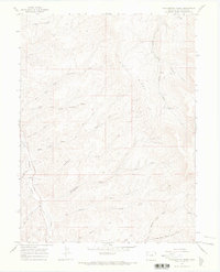
1964 Map of Philadelphia Creek
USGS Topo · Published 1968About this map
Philadelphia Creek meanders through this landscape of deep drainages and high plateaus, defining a topography shaped by seasonal water and livestock ranching. In the early 1960s, the area remained largely defined by its rural cattle heritage, anchored by the presence of Hefley Cow Camp near the eastern margin. The terrain is dominated by Big Ridge and the West Fork Spring Creek, while numerous named drainages like Vandamore Draw and McDowell Gulch suggest a history of local land use and landmark naming by early ranchers. While much of the land appears open, a modern Pipeline and a Jeep Trail cutting across the northwest corner indicate the early stages of industrial and recreational access. Small industrial traces, such as a Gravel Pit along a dirt road, point to the maintenance of the sparse infrastructure required to navigate this portion of Rio Blanco County.
Find a feature on this map
29 named features on this map. Tap any name to fly to it.
Don’t see what you’re looking for? This feature index may not catch every label — zoom into the map to look around manually.
Map Details
Editions of this 1964 Philadelphia Creek Map
This is the sole edition of this map. No revisions or reprints were ever made.
Other maps of this area

1907 · Rangely
USGS Topo · 1:125,000

1910 · Rangely
USGS Topo · 1:125,000

1954 · Vernal
USGS Topo · 1:250,000

1956 · Grand Junction
USGS Topo · 1:250,000

1958 · Vernal
USGS Topo · 1:250,000

1959 · Grand Junction
USGS Topo · 1:250,000

1960 · Vernal
USGS Topo · 1:250,000

1960 · Grand Junction
USGS Topo · 1:250,000

1962 · Grand Junction
USGS Topo · 1:250,000
1962 · Rangely
USGS Topo · 1:24,000