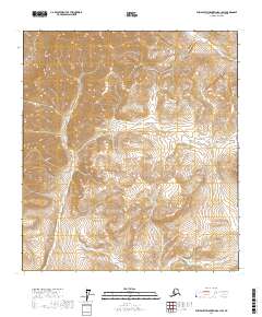
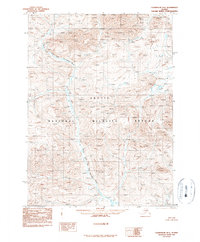
2017 Map of Philip Smith Mountains A-1 SW
USGS Topo · Published 2017About this map
The N Fork E Fork Chandalar River winds through the southeastern corner of this remote Alaskan terrain, illustrating the high-latitude drainage patterns characteristic of the Philip Smith Mountains. This 2017 survey by the U.S. Geological Survey maps a landscape of extreme vertical relief, where steep slopes and narrow valleys are defined by precise contour intervals. While largely uninhabited and devoid of named roads, the map serves as a critical reference for the hydrography and public land survey system divisions in the North Slope Borough, specifically within townships such as t16s r20e and t17s r21e. It provides a modern scientific record of a wilderness area where the movement of water and the orientation of the land remain the primary features of the geography.
Find a feature on this map
7 named features on this map. Tap any name to fly to it.
Don’t see what you’re looking for? This feature index may not catch every label — zoom into the map to look around manually.
Map Details
Editions of this 2017 Philip Smith Mountains A-1 SW Map
This is the sole edition of this map. No revisions or reprints were ever made.
Other maps of this area

1951 · Chandalar
USGS Topo · 1:250,000

1951 · Brooks
USGS Topo · 1:250,000

1956 · Chandalar
USGS Topo · 1:250,000

1956 · Philip Smith Mountains
USGS Topo · 1:250,000

1964 · Chandalar
USGS Topo · 1:250,000

1964 · Philip Smith Mountains
USGS Topo · 1:250,000
1971 · Philip Smith Mountains A-2
USGS Topo · 1:63,360
1971 · Philip Smith Mountains A-1
USGS Topo · 1:63,360
1990 · Chandalar D-2
USGS Topo · 1:63,360
1990 · Chandalar D-1
USGS Topo · 1:63,360