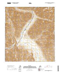
2017 Map of Philip Smith Mountains A-5 SE
USGS Topo · Published 2017About this map
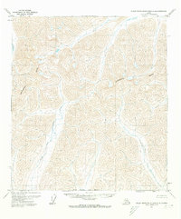
The Alaska Pipeline and Dalton Highway serve as the primary human corridor through this high-latitude terrain within the North Slope Borough. This infrastructure follows the narrow valley floor, flanked by steep mountain contours, providing the only overland link through this Arctic interior. The small outpost at Chandalar Shelf and the adjacent Chandalar Shelf Airport mark a critical logistical point in the Brooks Range foothills. The landscape is defined by the drainage systems of the Dietrich River flowing south and the Atigun River in the northern portion of the quadrangle. This 2017 survey shows the precise alignment of the pipeline and road as they navigate the varying elevations, illustrating the engineering required to maintain this vital energy and transport artery in a geography characterized by extreme relief and glacial watercourses.
Find a feature on this map
12 named features on this map. Tap any name to fly to it.
Don’t see what you’re looking for? This feature index may not catch every label — zoom into the map to look around manually.
Map Details
Editions of this 2017 Philip Smith Mountains A-5 SE Map
This is the sole edition of this map. No revisions or reprints were ever made.
Other maps of this area

1951 · Chandalar
USGS Topo · 1:250,000

1951 · Brooks
USGS Topo · 1:250,000

1956 · Chandalar
USGS Topo · 1:250,000

1956 · Philip Smith Mountains
USGS Topo · 1:250,000

1964 · Chandalar
USGS Topo · 1:250,000

1964 · Philip Smith Mountains
USGS Topo · 1:250,000
1971 · Philip Smith Mountains A-5
USGS Topo · 1:63,360
1971 · Chandalar D-6
USGS Topo · 1:63,360
1971 · Chandalar D-5
USGS Topo · 1:63,360
1971 · Philip Smith Mountains A-4
USGS Topo · 1:63,360